Practical Solutions for Salmon Passage
By Ronald M. Harriman
We Must Use Practical Rationality To Resolve Salmon Passage Up And Downstream
What We Cannot Control
Recognizing Natural Conditions
First condition: The controlling natural factors that dominate any solution.
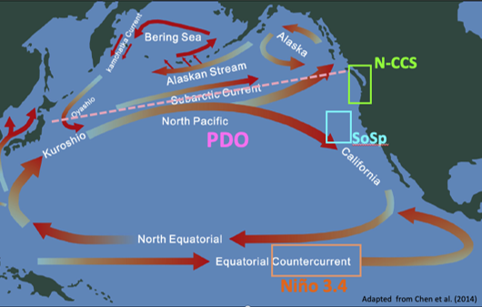
The primary impediment appears to be the Decadal Oscillation within the northern Pacific affecting the western coastal areas of North America rather than the eastern coastal areas of Asia. Limited salmonid harvest records published, not by the Russian Government, but by the wholesale salmon marketers, “Tradex,” indicates the Russian harvest on the western side of the Pacific will exceed the U.S. and Canadian harvest by 1/3 in 2020 and will exceed that in 2021. The reason for this discrepancy is identified as heated water affecting and depleting the natural food sources for the salmon in the northeastern section of the Pacific. Observation of the mapped ocean currents (see map below) within the Pacific establishes that the “Oyashio Current” flows south westerly cooling the Russian and Japanese eastern coast lines with arctic cold water from the Bearing Sea. Meanwhile the Border currents in the Northern Pacific carry heated water up from the tropics.
There are four main currents that circle the North Pacific forming an area, scientifically entitled a Gyre. From the equator aligned with northern Mexico a west flowing current carrying warm equatorial water flows westward toward Asia, turning north along the eastern coast of Japan and Russia, then east below the Aleutian Island chain toward the North American continent and then south joining the westward flow at the equator. Within this natural hydrological factor lies the hot spot called the Blob of periodically warmed water lying off the west coast of the U.S. and Canada. This warming sequence is entitled the “Decadal Oscillation.” When this occurs, it prevents cool nutrient filled water from coming to the surface which provides the ocean food chain and in turn reduces the number of salmon entering our rivers. The cold descending “Oyashio Current” with its upwelling nutrients is obviously the most likely scenario for the higher salmon numbers on the eastern coast of Russia and Japan.
Second condition: The natural annual solar heat in the Snake and Salmon rivers.
This natural condition has historically been monitored and recorded, prior to the construction of the Snake River Dams, not only by the USGS, but also by USACE. The heat blamed for fish death in the four (4) Snake River Dams within Washington State is a natural phenomenon reaching 23.8 C, or 75 F during the spawning months, July through September. Considering the world temperature has only increased by 1.5 F in the last 120 years, the historic salmon runs had to be acclimated to the warmth of the water. This heat factor is consistent, and also recorded in the Snake River 300 miles upstream at the Bliss, Idaho USGS monitoring site USGS 13154500 SNAKE RIVER AT KING HILL ID. It is also true of the undammed Salmon River which is recorded at the USGS site at White Bird, Idaho USGS 13317000 SALMON RIVER AT WHITE BIRD ID. It is both puzzling and curious that during the last fifty-year period this consistently recorded and available factor was not recognized, and if so, repressed, as a prominent natural condition by the EPA when requiring a Cold-water Salmonid Spawning (CWSS) Temperature of 13.5 C, or 56.3 F during the spawning season. This designated EPA/CWA temperature, historically, was never attained during salmon spawning months within Idaho’s Salmon Rivers, excepting the Clearwater River. It is not attained in any of the water in southern Idaho other than the Eastern forks of the Snake Rivers north and east of Idaho Falls, Idaho. Those rivers were never salmon spawning rivers as they are blocked of salmon access by the natural rhyolitic cliffs forming Shoshone Falls and Twin Falls in the Magic Valley area.
Third condition: Human caused enhanced predation within the Columbia and Snake rivers.
A variety of non-native predatory fish have been introduced, either surreptitiously or as a fishery management effort. These alien fish have had a significant impact via predation on smolts. Eliminating these species, such as bass, walleye and northern pikeminnow would require poisoning the rivers which would also eliminate the salmon and steelhead smolts or spawners.
What We Can Control
Engineering, Predator Control, By-Passing the Dams And Their Lakes
USCAE, USFW, and Bonneville Power have engineered and re-engineered the fish ladders to the point that reportedly 95% of the returning spawners navigate the dams successfully. Bypassing the dam’s physical structure appears to no longer be a problem for returning Chinook spawners.
Orca predation. Prior to reaching Bonneville Dam large Chinook exceeding 40” in length suffer heavy predation from Orcas. According to a 2019 study by the University of Washington, Orcas have tripled in population and are the suspected reason there appear to be no longer any large Chinook in the ocean. Salmon recovery may require thinning these pods.
Also, at the Bonneville Dam, returning salmon face heavy predation by Sea lions. Attempting to control this condition NOAA is now allowing the Tribes and others to remove a limited number of both Steller and California Sea Lions in the river and estuary.
Problems unresolved:
- As noted, lacking at this time are effective solutions for river avian and fish predation of smolts, nitrogen narcosis reduction, heat control, or continuous flowing water.
- Heat of the slack water within the dam lakes are deadly to the returning Sockeye.
Resolution To Ameliorate
Existing Geological Features:
Satellite observation of the Columbia and Snake River channels allows somewhat accurate elevations of dams, locations of the confluence of tributaries, and the geographic contours along the Columbia and Snake Rivers. River mileage is estimated to be 360+- miles and the fall in elevation from Lewiston to the Bonneville dam is shown to be 687’+- or 1.9’ per mile which indicates slowly moving water.
Practical Solutions for Salmon Passage
This canal would need to be built with riverine attributes, placed on the river and lake side following closely to the railway right of way’s where possible on the eastern and southern sides of the Columbia and Snake Rivers from the Bonneville Dam to Lewiston, Idaho. Estimated size of the canal would be a channel 60’ wide with 45 deg. Side slopes and a depth of 14’, requiring 30 c/y of excavation per l/f, 3.5+- c/y of polypropylene fiber reinforced gunite over geocloth per l/f. It should have a flowing water capacity of 400 CFS at Lewiston and 600 CFS at Bonneville. Excavation can be minimized depending on the strata by utilizing the excavated material as shoulders/berms. Where needed this could be a cast in place or prefabricated concrete above ground structure. Considering the construction cost to be somewhere in the neighborhood of a 2-lane interstate highway the cost of construction alone should be around $900,000,000. Tributaries coming into this channel can be accommodated with flumes. Collections of Smolts will have to use the same methodology now used for barging before being placed in the Artificial River/”Canal”. The USCAE engineers are more than capable of this elementary design and engineering.
Advantages Of Using This Method
- This method would leave 95% of the present existing infrastructure in place, keep the clean energy hydro power production, provide the water storage needed to provide agriculture and domestic water if the Global Warming conditions prove true. It will also allow continued use of the lakes behind the dams for recreation, barging and warm water fishing.
- It will provide a continuous unimpeded flow of water from Lewiston, Idaho to the river below Bonneville Dam allowing the smolts to avoid all of the fatal hazards now affecting their passage and deaths. This also is the method that will save the Red Fish Lake run of Sockeye by providing an unimpeded continuous flow of water back to the spawning grounds for returning salmon. I contend this, as the Sockeye run has now dwindled nearly beyond recovery with the dams in place, and as the temperature of the water has not changed from pre-settlement conditions by more than 1.5 F, these two factors undeniably identify the only logical method to save the run will require a moving body of water like a river.
- By utilizing solar panels periodically along its length this artificial channel, and the body of water within it, could be aerated as required and if needed, operate cooling stations when needed. The panels will also provide power for camera observation and allow pumping water from the canal to water trees for natural shading as is recommended by the Clean Water Act (CWA) and EPA for cooling of streams and rivers along the entire length.
- It will eliminate the majority of fish predation of smolts and with a 60’ width can easily be screened in areas where avian predation is prominent.
- It is also a more economic utilization of water. In 2020, Idaho was required to deliver 487,000 acre-feet of water for salmon recovery and Oregon was required to deliver 267,000 acre-feet. Washington has no published allocation of water for salmon recovery. The proposed canal (artificial river) would require a flow of less than 434,380-acre feet annually. This would allow both Idaho and Oregon the annual beneficial use of 319,629-acre feet of water for agriculture.
- As it will be an independent flow of water, where and when needed, the water flow can be diverted for needed repairs.
- The design of the canal should include periodic riffles, pools, with cobbles along the bottom similar to the natural riverine conditions. This flow notably drops only 1.9’ per mile, but the spillway action of the flow descending at each dam will aid in the flow speed of the water through this channel.
- Public viewing sights should be established, and to accommodate Tribal Treaties with the U.S. it will be necessary to provide periodic locations to allow a limited number of salmon to be harvested. This will require an enforceable agreement with the affected tribes.
In summation: Salmon Recovery has a reported $17 billion cost as of 2020 the utilization of which has resulted in falling numbers of returning salmon to the spawning grounds. Idaho’s Rep. Simpson is attempting to spend another $33 billion to increase salmon numbers with methods that are shown above to be not only impractical but scientifically, and economically irrational. The entire placement of this channel has a similar cost to one year’s Salmon recovery at $900 Million.
This preceding suggested solution will not return the runs to historical numbers, but it will dramatically improve the numbers by eliminating the predation and the loss of returning Sockeye without harming the present conditions.
Ronald M. Harriman Chairman of the Concerned Citizens of Canyon County an Idaho Registered Non-Profit.
For more information go to the Concerned Citizens of Canyon County website.